Parts of Midwest, South hit with rain and flooding amid tornado recovery
5. April 2025
Torrential rains and flash flooding battered parts of the Midwest and South on Friday, killing a boy in Kentucky who was swept away as he walked to catch his school bus. Many communities were left reeling from tornadoes that destroyed entire neighborhoods and killed at least seven people earlier this week.
Another man died in Nelson County, Kentucky, Gov. Andy Beshear confirmed, bringing the total of weather-related fatalities to nine people this week.
Round after round of heavy rains have pounded the central U.S. for days, and forecasters warned that it could persist through Saturday. Satellite imagery showed thunderstorms lined up like freight trains over communities in Arkansas, Tennessee and Kentucky, according to the National Weather Prediction Center in Maryland.
The center warned of “potentially historic” amounts of rainfall for some places through Sunday with some places getting 10-15 inches or more along with a “catastrophic, life-threatening flash flooding risk,” especially in the lower Ohio Valley, mid-South and Ozarks.
The bull’s-eye centered on a swath along the Mississippi River and included the more than 1.3 million people around Memphis, Tennessee.
More than 90 million people were at risk of severe weather from Texas to Minnesota to Maine, according to the Oklahoma-based Storm Prediction Center.
Ryan C. Hermens / AP 
In Frankfort, Kentucky, a 9-year-old boy died in the morning after floodwaters swept him away while he was walking to a school bus stop, Gov. Andy Beshear said on social media. Officials said Gabriel Andrews’ body was found about a half-mile from where he went missing.
The downtown area of Hopkinsville, Kentucky — a city of 31,000 residents 72 miles northwest of Nashville — was submerged. A dozen people were rescued from homes, and dozens of pets were moved away from rising water, a fire official told the Associated Press.
There are 390 road closures across the state right now due to flooding, mudslides and rockslides, Beshear said.
“The main arteries through Hopkinsville are probably 2 feet under water,” Christian County Judge-Executive Jerry Gilliam said earlier.
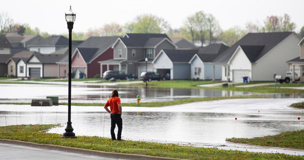
Greensburg, a city in Southern Indiana, reported road closures and severe flooding on Saturday. Every community was experiencing “infrastructure that is extremely over regular capacity, which is leading to localized flooding,” the city wrote on social media.
A corridor from northeast Texas through Arkansas and into southeast Missouri, which has a population of about 2.3 million, could see clusters of severe thunderstorms late Friday. The National Weather Service’s Oklahoma-based Storm Prediction Center warned of the potential for intense tornadoes and large hail.
Tornadoes leave a path of damage, and more could be coming
At least two reports of observed tornadoes were noted Friday evening in Missouri and Arkansas, according to the National Weather Service.
“TAKE COVER NOW!” the weather service said on X in response to the one on the ground around the small Missouri town of Advance.
Those killed in the initial wave of storms that spawned powerful tornadoes on Wednesday and early Thursday were a least five in Tennessee and one each in Missouri and Indiana, according to a CBS News count. They included a Tennessee man and his teen daughter whose home was destroyed, and a man whose pickup struck downed power lines in Indiana. In Missouri, Garry Moore, who was chief of the Whitewater Fire Protection District, died while likely trying to help a stranded motorist, according to Highway Patrol spokesperson Sgt. Clark Parrott.
Jon Cherry / AP 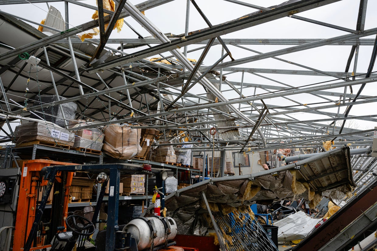
Tennessee Gov. Bill Lee said entire neighborhoods in the hard-hit town of Selmer were “completely wiped out” and said it was too early to know whether there were more deaths as searches continued. He warned people across the state to stay vigilant with more severe weather predicted.
George Walker IV / AP 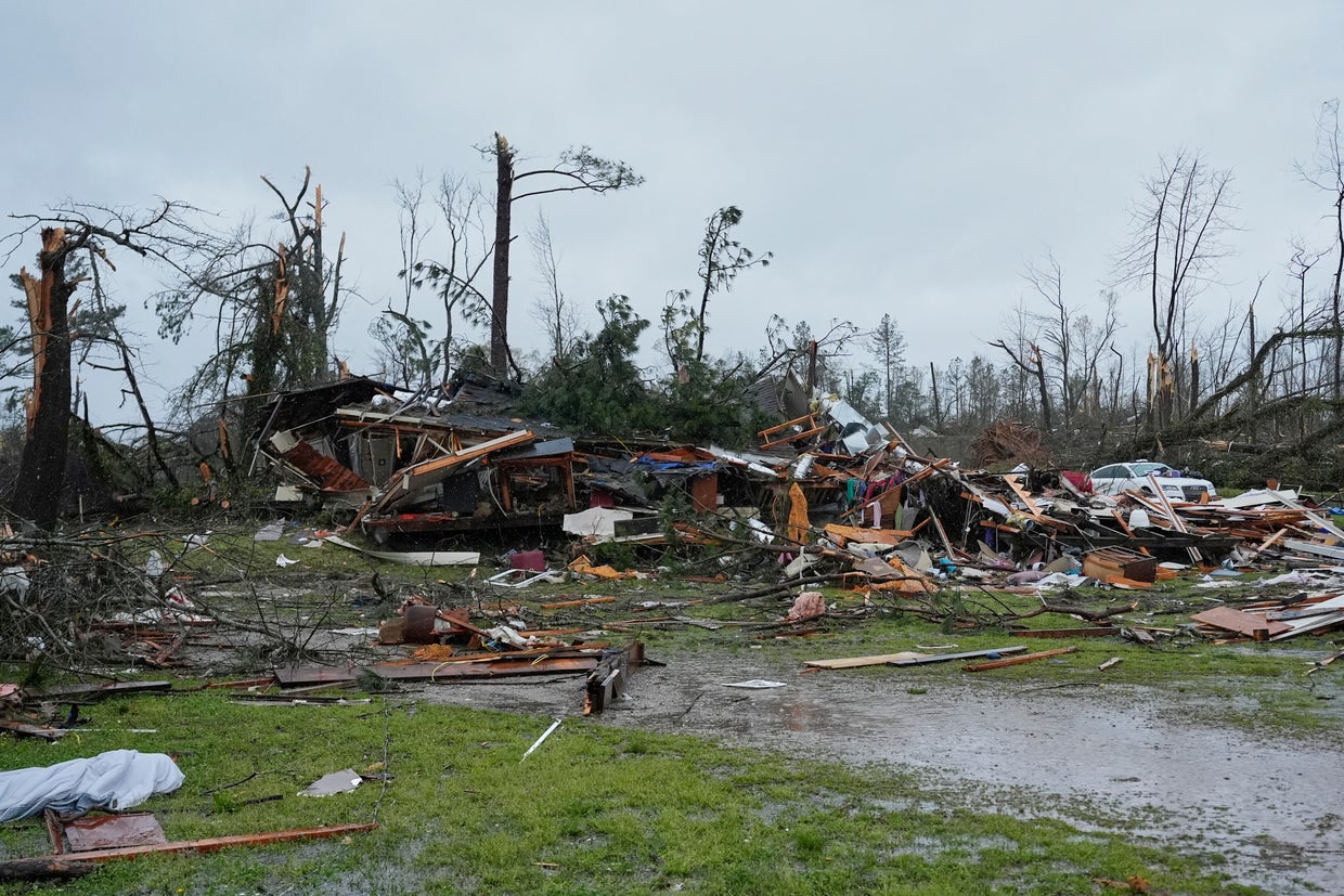
“Don’t let your guard down,” he said during a Thursday evening news conference. “Don’t stop watching the weather. Don’t stop preparing yourself. Have a plan.”
With flattened homes behind him, Dakota Woods described seeing the twister come through Selmer.
“I was walking down the street,” Woods said Thursday. “Next thing you know, I look up, the sky is getting black and blacker, and it’s lighting up green lights, and it’s making a formation of a twister or tornado.”
By late Thursday, extremely heavy rain was falling in parts of southeastern Missouri and western Kentucky and causing “very dangerous/life threatening flash flooding” in some spots, according to the National Weather Service.
Heavy rains were expected to continue there and in other parts of the region in the coming days and could produce dangerous flash floods capable of sweeping away cars. The potent storm system will bring “significant, life-threatening flash flooding” each day, the National Weather Service said.
Water rescue teams and sandbagging operations were being staged across the region, and the Federal Emergency Management Agency was ready to distribute food, water, cots and generators.
Water rescues were already underway in flooded parts of Nashville, Tennessee, where the rain could persist for days after an unnerving period of tornado warnings that drained the batteries of some city sirens, the fire department said.
Western Kentucky prepared for record rain and flooding in places that normally do not get inundated, Beshear said. At least 25 state highways were swamped, mostly in the west, according to a statement from his office Thursday.
Flash flooding is particularly worrisome in rural areas of the state where water can quickly rush off the mountains into the hollows. Less than four years ago, dozens died in flooding across eastern Kentucky.
Extreme flooding across the corridor that includes Louisville, Kentucky, and Memphis, which have major cargo hubs, could also lead to shipping and supply chain delays, said Jonathan Porter, chief meteorologist at AccuWeather.