They knew it could happen: History warned of the Central Texas Guadalupe River flood
9. July 2025
Texas hydrologists working with the National Weather Service say they recognized the conditions last Thursday that could lead to catastrophic flooding on the Guadalupe River.
And they say, based on past events, this kind of outcome was a known risk.
The I-Team has learned that’s why the hydrologists say their forecast partners at the National Weather Service issued a flash flood watch in parts of that area up to 10 hours before the water swept through campsites along the river, killing multiple people and leaving others clinging to trees.
“On Thursday, we made the call yeah, this is going to be an event,” said Jason Johnson, a lead hydrologist at the West Gulf River Forecast Center in Fort Worth. “The hardest part is pinpointing where that rainfall is going to occur.”
The Fort Worth team monitors rivers across the western Gulf, including the Guadalupe.
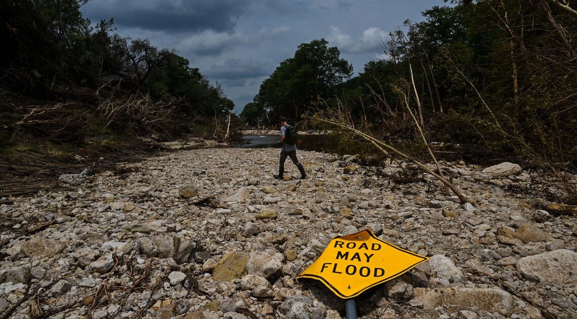
In what experts call “Flash Flood Alley,” the terrain reacts quickly to rainfall steep slopes, rocky ground, and narrow riverbeds leave little time for warning.
“It’s known as ‘Flash Flood Alley…’ it responds very fast,” Johnson said.
History repeating
The I-Team reviewed National Weather Service and historical crest records and found that the Guadalupe River has experienced major flooding more than a dozen times in the last century.
On July 4, preliminary data shows the Guadalupe River at Hunt reached 37.52 feet.
The I-Team has learned the river in that area has been even higher four other times since tracking began, and it’s reached more than 25 feet on 15 other occasions.
These events include deadly flash floods that have taken lives, inundated homes, and overwhelmed campsites.
Hydrologists say the signs were there. In 1987, floodwaters rose to 31 feet in Comfort. Ten people died including children after camp buses were caught in the rising current.
Similar deadly floods happened again in 2015. In 1869, the Guadalupe crested to above 40 feet.
“Each event is different,” Johnson said. “But they can all have the same consequences. You can’t say this was worse than another because it impacted someone.”
So how could this still happen?
Experts say the physical danger of rising floodwaters is often underestimated.
“Once you get into those kinds of depths and flows, it’s almost impossible to get away,” Johnson said. “Even six inches of water can knock you off your feet. Two feet of water can sweep away a car.”
The hydrologists say the region has become more densely populated in recent years. The increased presence, both residential and recreational, can make it harder to evacuate quickly when the water starts rising.
The hydrologists say the timing of the storm overnight may have played a major role also. Even when warnings go out, they’re not always received. Phones may be turned off. People are asleep.
“Weather is 24/7… but when it’s overnight, it’s hard to get messaging out,” Johnson explained. “The message may go out but are people awake to receive it? That’s always the tough part.”
He added: “We could be doing everything right, and the message gets out, but it’s not received. That’s the heartbreaking part.”
Despite the tragedy, Johnson said his team was staffed and ready. Forecasting models were in place. More scientists were on standby.
“We had our best people on shift… everyone was utilized,” he said.
They also say some high-risk areas may lack reliable systems for receiving warnings raising questions about how alerts reach people in time during fast-moving events like this one.
More perspective: Texas Service Storms Association
A spokesperson for the Texas Severe Storms Association told CBS News Texas: “Campsites and homes in high-risk areas like the Hill Country should be relocated to higher ground and properties within the flood zone should be utilized only for day use.”
What comes next
Johnson said this tragedy, like others before it, will drive change.
“Our mission is protection of life and property,” said Johnson. “When you hear loss of life, it’s very tough. We’ll all be hard on ourselves, asking how we can do better.”
He said meteorological models have improved since major flooding in 2002, and more updates are underway. New floodplain maps, artificial intelligence tools, and enhanced communication systems are all being considered.
What you can do
Officials recommend always having multiple ways to receive emergency alerts including a portable weather radio, a smartphone with alerts enabled, and staying tuned to local news.
If you’re camping or living near water in flood-prone areas, know your escape routes and check forecasts frequently, especially during storm season.